This website or its third-party tools use cookies which are necessary to its functioning and required to improve your experience. By clicking the consent button, you agree to allow the site to use, collect and/or store cookies.
I accept

yourmoray.com

Resources for people in or interested in Moray, Scotland

  • Home
  • Moray Gallery
  • Sample Newsletter
You are here: Home / Archives for Places in Moray

Sueno’s Stone – Highlight of the Pictish Coast

January 27, 2022 by peter brash

David Sellar describes Sueno’s Stone as “one of the most intriguing monuments in Scotland”.

He cites Joseph Anderson’s description with gentle mockery (it shows “pardonable exaggeration”, according to Sellar).

In Anderson’s words it’s ‘a unique monument, the most interesting and inexplicable of its kind in existence, either in this country or any other’.

It is visible from the A96, as it bypasses Forres, but blink and you will miss it.

Instead, from the eastmost roundabout on the A96 giving access to the town, make your way along Victoria Road (B9011) and turn right into Findhorn Road. This is a dead end and has you almost completely doubling-back on your westerly direction along Victoria Road.

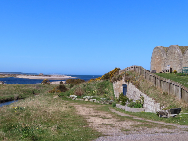
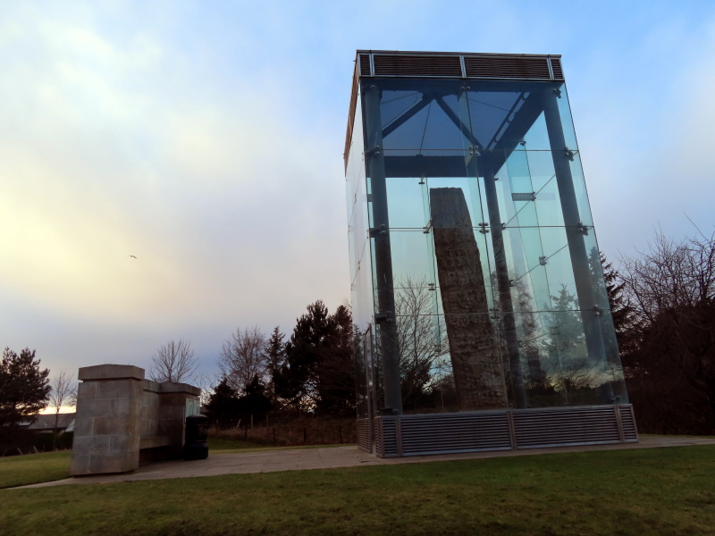
There is no official car park for Sueno’s Stone but the on-street parking should be fine. And entry to this Historic Scotland visitor attraction is free.

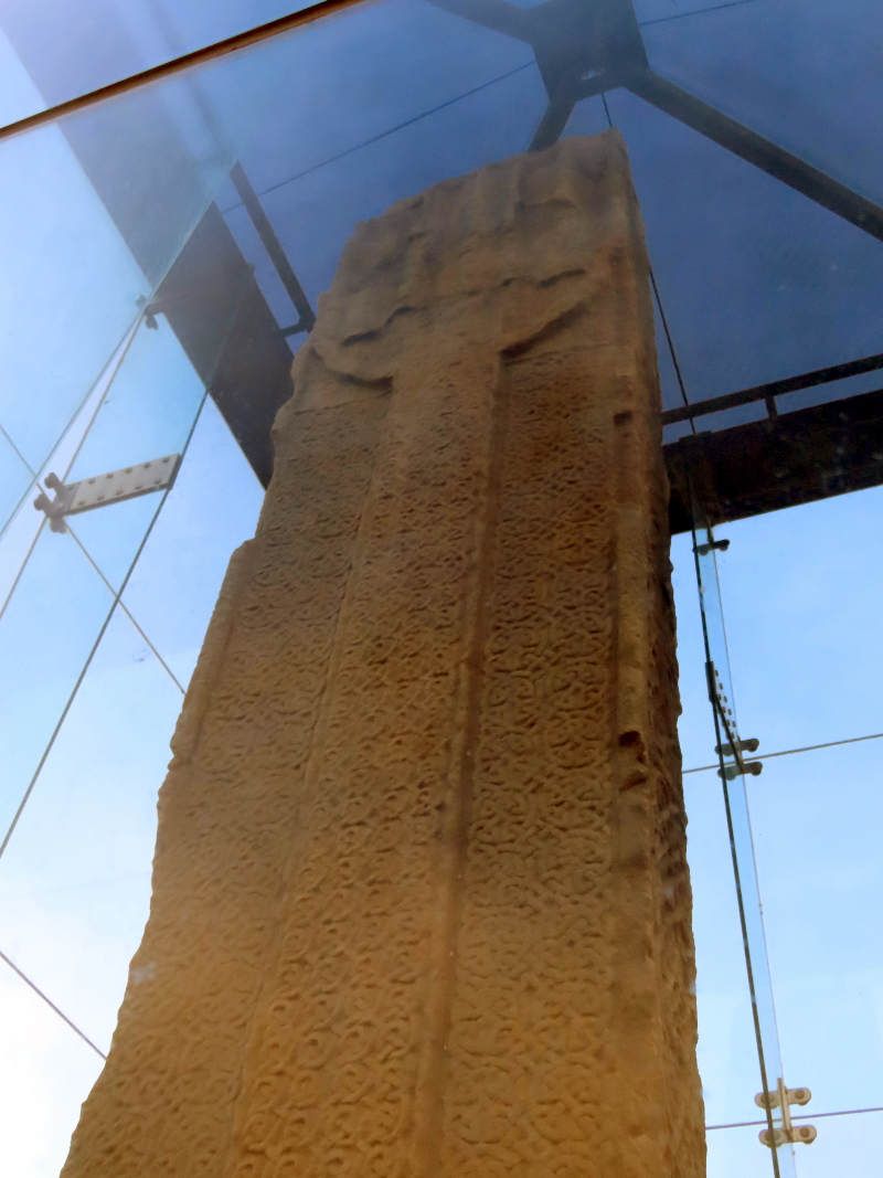
Weighing over 7 tons and standing 6.5m (21 feet) in height, it is an imposing, decorated Pictish stone.

Carved in the 9th or 10th Century from local sandstone, it is an artistic masterpiece and seems almost impossibly enormous for its age and relatively slender design.

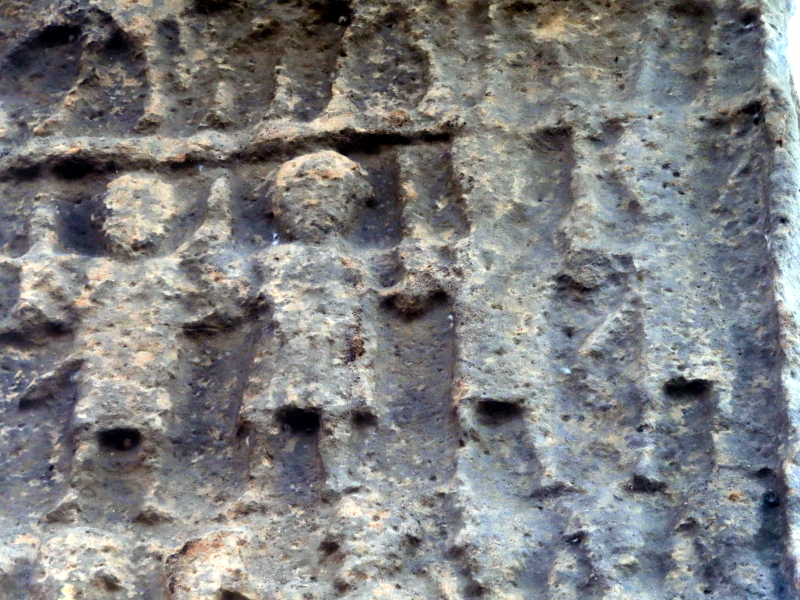
It is Scotland’s tallest surviving cross-slab and one of the most richly-carved examples of Pictish art in the country.

What the artwork commemorates is still the subject of discussion and unlikely ever to be definitively settled.

It seems to tell a tale of warlike slaughter.

On the front side, there is a ring-head Christian cross. It takes up most of that face of the stone. Its shaft, base and background are infilled with interlaced “celtic knotwork” decoration.

Suenos-Stone-Ringed-Cross-Side

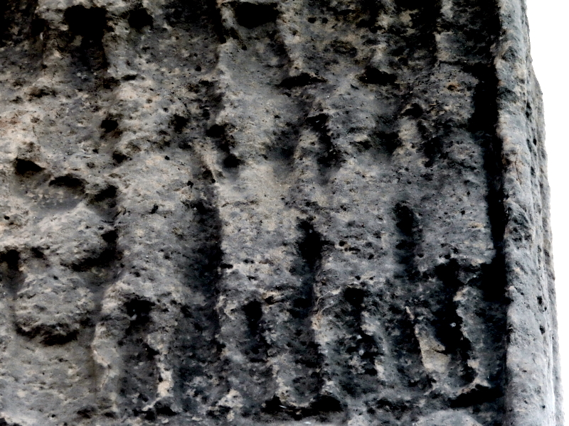
But it’s the abundance of motifs on the back which is most striking.

Across 4 separate panels, densely-packed, almost geometrically abstract-looking groups of figures ride into battle. They strike each other on the head with swords. Some appear to be beheaded corpses.

Suenos-Stone-Detail-Showing-Warriors

We have a number of possible options for the “true story” of Sueno’s Stone.

In the 10th Century, for example, when Scotland consisted of several different Kingdoms, Dubh (anglicised as Duff but meaning black or dark in modern Gaelic) was King of Alba (King of the Scots) from 962 to 967.

To place him better on a timeline, it may help to know that King Duncan the First’s dates were 1034 -1040 and Macbeth’s 1040 – 1057.

Dubh was reportedly murdered at Forres in about 967 as the result of an internal dispute among the Scots. Sueno’s Stone may be a monument to Dubh, erected by his brother.

Another possible version is linked to the man apparently known as “Sueno” – King Sweyn Forkbeard (King of Denmark from 986 to 1014) – and a battle between his Viking forces and the Scots. Because Sueno’s Stone displays mainly battle scenes, this would fit with the theory that the Picts must have had conflicts with the Vikings.

A further possibility – if the battle scene represented is one we know took place – is that it could depict a victory of Kenneth MacAlpin (who ruled from 843 to 859) or of his successor, Donald I (860-863). Their reigns strengthened the House of Alpin’s hold on this part of Scotland. In that case, the inauguration scene could refer to the enthronement of either of these important kings.

There is evidence to suggest that the stone fell or was toppled at some point around the 17th Century.

It was uncovered again within a century or so – in 1726 – and re-erected nearby. It was at this time that the name “Sueno’s Stone” was invented.

In the early 1990s, the stone was encased in reinforced glass to minimise further erosion.


Join our Newsletter for a weekly Moray update.

Delivered straight to your inbox. (See the sign-up form below).

Lossiemouth set for access to its East Beach again at last

January 16, 2022 by peter brash Leave a Comment

Lossiemouth is blessed with two fantastic beaches – the East Beach and the West Beach.

Access to the West Beach has not always been straightforward although there is a convenient public car park at its east end. Large stones washing up on the concrete ramps which provide pedestrian access can make the start and end of a walk to Covesea Lighthouse challenging.

The problem with access to the East Beach has become widely known.

(In case you don’t know, the pedestrian bridge was closed to the public from July 2019 due to safety concerns).

But if you’re not familiar with the unusual course of the River Lossiemouth in its lower reaches – running parallel to the coastline for a mile or two – it can be a bit difficult to understand how exactly the access problem has arisen. Essentially, the East Beach is a peninsula of sand (running east to west) which ends just short of Lossiemouth Esplanade because the mouth of the River Lossie cuts through the dunes (flowing south to north) at that point.

As we go on to discuss, this need to cross water – the River Lossie – to get from the town to the East Beach has, to date, been solved by 2 separate bridges (the first one built in the early 20th Century).

The later bridge, from the Seatown of Lossiemouth, is the one which has had to be closed.

Lossiemouth Community Development Trust (LCDT) have released a short film explaining their efforts first to repair and then replace the bridge.

The story begins in 2014, when LCDT was formed..

As the film sets out, Lossiemouth is home to around 8,000 people.

The people and buildings are protected from the waters of the Moray Firth by stone seawalls – and by magnificent sandy dunes.

Unfortunately, the dunes at the East Beach are only accessible via the solitary footbridge.

As LCDT Chairman, Alan MacDonald, explains, “The Development Trust was formed in late 2014. In early 2015, a five-year plan was put together following consultation with the local community. At the top of the agenda on that plan was the East Beach Bridge which, at that time, was in a poor state and had had no maintenance for the previous 20 years.”

LCDT therefore set about trying to establish the structural safety of the bridge and, at the same time, discover the true ownership of the bridge.

Back in those early days, from 2015 onwards, LCDT had no idea that some years later they would be involved in a major project leading to the replacement of the bridge.

You’d have thought that the question of who owns the bridge would be simple enough to answer.

Especially when it’s something as “important” as a bridge.

However, LCDT were to find the ownership issue was quite a puzzle, in practice.

It turns out that the “original” bridge was in a different location altogether – from the Esplanade to the west end of Lossiemouth East Beach.

That bridge was built in 1908.

It was then moved in 1918 to its present location at Seatown. (Lossiemouth is an amalgamation of three villages: Stotfield; Branderburgh; and Seatown).

The move was required because the Esplanade bridge was restricting access for boats to the “Old Harbour”, which was upstream of the bridge.

The bridge was owned by a company called the Lossiemouth Old Harbour Commissioners (LOHC).

LOHC ceased to exist by around the middle of the 20th Century, at the latest – which became a bit of a problem for the ownership of the bridge later on.

“Ownerless” property in Scotland generally falls into the ownership of the Crown.

But it does so in such a way that the Crown does not need to do anything with the property if it doesn’t want to.

The procedure for LCDT – over a period of about 18 months – was to negotiate with the person who looks after matters of ownership on behalf of the Crown. They’re called the Queen’s and Lord Treasurer’s Remembrancer (QLTR).

LCDT had to locate and provide to QLTR various documents from public records, including the National Library of Scotland.

The upshot was that QLTR agreed that the ground in question had fallen into the ownership of the Crown. The Crown didn’t want it, though.

On 03 October 2017, the Crown issued a Notice of Disclaimer of Ownership.

Was this progress or a backward step?

One thing was for sure: with no owner in sight, the question “who will own and maintain this bridge?” became intrinsically linked to the question “who will pay for this bridge at all?”

When LCDT had first embarked on the bridge project, they thought (optimistically) that all they had to do was discover who owned the bridge and then guide them as to what they could do to repair it.

By October 2017, of course, it was clear that no one owned the bridge.

LCDT arranged for professional engineering surveys on the bridge to establish the extent of the problems and get a feel for the likely cost of repairs.

The reports were pessimistic. The parapet of the bridge was in very poor repair. It would have to be repaired in full.

From the end of 2017, LCDT had been lobbying politicians for funding. Local councillors and Moray’s MSP were supportive but the amount of money required was too great for there to be any hope of a public appeal raising enough revenue.

Furthermore, though LCDT had legitimate concerns based on the structural surveys, there was no apparent urgency for major works at that stage. The counter-argument was: “The bridge is open; why are you worried about it?“

And there was an even bigger snag.

The wood which supported the parapet was 100 years old. You’d be putting a new parapet on top of wood which was in uncertain condition – particularly the part of the structure which gets submerged by the combination of river and tidal water.

This inability to get to the heart of the structural integrity of the bridge meant no one could reasonably fund a repair to the existing crossing.

Lossiemouth East Beach, looking east towards Spey Bay.

Following the closure of the bridge to the public in July 2019 due to safety concerns, oddly enough, the funding stream opened up to an extent.

When it became apparent both locally and beyond that the bridge was closed and no simple alternative access existed, interest increased dramatically – especially when it was clear there was no likelihood of a bridge crossing being re-established any time soon.

Against this background, LCDT continued with their quest to find funding.

Ultimately, The Scottish Government agreed to fund the project, subject to a feasibility study.

An options appraisal identified three possibilities.

  • Firstly, to replace the current bridge in the same position.
  • Secondly, to build at a new location downstream of the present bridge but not as far down as the original Esplanade bridge position, or
  • Thirdly, to rebuild the bridge in its original 1908 position and provide access from the Esplanade.

The Scottish Government stipulated that any new bridge had to be “best value”.

In practice, that meant that the shorter the span, the lower the cost.

Unfortunately for the majority of Lossiemouth residents – who would like to see the bridge remain in its present position – the present bridge is one third longer than it would be to build the bridge from the Esplanade. In other words, the costs involved would be at least one third more to rebuild the bridge in its present position.

Given that the “best value“ option was the only one on the table, it was an inevitable decision to build the replacement bridge from the Esplanade.

The whole community has helped in moving the project to the point where a new bridge from the Esplanade to the East Beach – at a cost of £1.8 Million – may be operational as early as April 2022.

You can view the LCDT film below.

You can view the 24/7 livestream below.

https://www.youtube.com/watch?v=MUX9J0yM9CA

Other articles about the East Beach Bridge post-2015

The Lossiemouth Community Development Trust website contains a couple of articles – from 2016 and 2017 – setting out the stage LCDT had reached in terms of research and investigations into the health and ownership of the bridge.

Lossiemouth Seatown Bridge Ownership up for grabs

Lossiemouth Seatown Bridge in failing health report warns

Lossiemouth East Beach Bridge with the town and Esplanade beyond.

Scottish Dolphin Centre at Spey Bay (is not ‘Dolphin World’)

August 30, 2021 by peter brash

I was once in the car park at the Scottish Dolphin Centre and heard a grumble.

A bus trip had stopped for a visit and something had clearly been lost in translation as to what to expect.

You won’t get the chance to pet dolphins or watch them jump through hoops.

It’s NOT like this at the Scottish Dolphin Centre…

What you will find at the centre, beside Tugnet Ice House, Spey Bay (at the mouth of the River Spey), is one of the best places in Scotland to view dolphins from the land.

The Moray Firth is famous for its resident population of Bottlenose Dolphins.

Though the population (of about 200 dolphins) is based here, its members travel far and wide. The dolphins are individually named and some are easily identifiable. For example, Spirtle is marked by the remnants of sunburn from a stranding she survived a few years ago. Both she and other Moray Firth dolphins have been seen as far away as the south-west of Ireland.

This is the most northerly population of dolphins in the world. They are a hardy bunch and individuals are large in comparison to the average size for dolphins.

Entry to the Scottish Dolphin Centre is free of charge.

Salmon is part of the dolphin’s diet and it’s appropriate that the centre should be in a building adjacent to an ice house. This was used historically as a store for ice which was used to preserve salmon caught for human consumption.

Tugnet Ice House, Spey Bay, with the mouth of the River Spey and distant Lossiemouth.

The centre is run by volunteers.

It is owned by WDC, Whale and Dolphin Conservation. WDC is the leading charity (Scottish Charity No. SC040231) dedicated to the protection of whales and dolphins. Their primary aim is to secure a world where every dolphin and whale is free and safe.

Among its attractions are:

  • Film from animal observation cameras.

  • A “dry” dive under the surface of the Moray Firth, providing an audio-visual experience of the sea depths.

  • A cosy cafe.

From outside, whether you’re looking out to sea or across/into the mouth of the River Spey, there is a lot of wildlife on offer, including: dolphins; seals; jumping fish; osprey; and otters.

Guided walks are available through the centre or you can amuse yourself on the pebble beach, with views east towards the Bin of Cullen (hill) and west to Lossiemouth. The Speyside Way leads upstream on the River and a relatively short walk takes you to the Spey Viaduct and the pedestrian/bicycle track across to the other side at Garmouth. From the bridge, views inland (to the south) extend as far as Ben Rinnes.

On the Spey Viaduct, River Spey, Garmouth, Moray.

Spey Bay is not the only land-based point from which to view dolphins in Moray.

Other possibilities include the headland viewing platform at Burghead (which has commanding views round more than 180 degrees), and the harbour walls at Hopeman and Lossiemouth.

Various options are available if you would like to go out on a ‘rib’ into the firth to seek out dolphins at other sea creatures close-up.

Ben Aigan, Ben Rinnes and the Spey Viaduct at Garmouth seen from the Scottish Dolphin Centre, Spey Bay, Moray.

Moray Distillery Tour for You

August 29, 2021 by peter brash

Moray boasts the greatest concentration of whisky distilleries in the world.

Visiting a malt whisky distillery is a rewarding experience.

Hardcore whisky fans will probably want to visit more than one or two.

It’s impossible to put together a “fair” tour of only a few distilleries in Moray.

Omitting any of those which offer tours is in some way unfair.

Each whisky is unique. Every expression of each whisky is unique.

We’ve also covered some of the other distilleries elsewhere on this site in their own articles – for example, Benriach.

To avoid having to make a controversial choice ourselves, this selection is nicked from the German version of the Lonely Planet Guide to Scotland.

Aberlour

At Aberlour, you get an informative tour with a good tasting experience. Aberlour is part of the Pernod Ricard Group.

Glenfarclas

An independent distillery – owned by J & G Grant – at Ballindalloch, about 5 miles south of Aberlour, on the Grantown road, Glenfarclas is is clearly signposted from the A95.

Glenfiddich

There’s a lot going on in and around Glenfiddich, with its neighbouring distilleries of Balvenie and Kininvie. Under the banner of owners, William Grant & Sons, Glenfiddich is another independent distillery. The tour usually includes a visit to the bottling hall, which is a relatively unusual feature of the distillery – most distilleries bottle their product off-site. Glenfiddich is the top-selling single malt whisky in the world.

The Macallan

The Macallan opened a brand new distillery, with visitor centre, in 2018 at its Easter Elchies site, above the River Spey near Craigellachie. It provides an interesting contrast to the ‘traditional’ malt whisky distillery tour offered by those further up in this list. The Macallan is owned by the Edrington Group.

Looking towards Craigellachie from inside The Macallan Distillery

Speyside Cooperage

It is not a distillery but at Speyside Cooperage you can observe close up the fascinating craft of the cooper (cask builders and repairers). The Cooperage is beside the road from Craigellachie to Dufftown.

Next Page »

Search this website

© 2025 yourmoray.com · Rainmaker Platform

Privacy Policy