This website or its third-party tools use cookies which are necessary to its functioning and required to improve your experience. By clicking the consent button, you agree to allow the site to use, collect and/or store cookies.
I accept

yourmoray.com

Resources for people in or interested in Moray, Scotland

  • Home
  • Moray Gallery
  • Sample Newsletter
You are here: Home / Archives for History

Sueno’s Stone – Highlight of the Pictish Coast

January 27, 2022 by peter brash

David Sellar describes Sueno’s Stone as “one of the most intriguing monuments in Scotland”.

He cites Joseph Anderson’s description with gentle mockery (it shows “pardonable exaggeration”, according to Sellar).

In Anderson’s words it’s ‘a unique monument, the most interesting and inexplicable of its kind in existence, either in this country or any other’.

It is visible from the A96, as it bypasses Forres, but blink and you will miss it.

Instead, from the eastmost roundabout on the A96 giving access to the town, make your way along Victoria Road (B9011) and turn right into Findhorn Road. This is a dead end and has you almost completely doubling-back on your westerly direction along Victoria Road.

There is no official car park for Sueno’s Stone but the on-street parking should be fine. And entry to this Historic Scotland visitor attraction is free.

Weighing over 7 tons and standing 6.5m (21 feet) in height, it is an imposing, decorated Pictish stone.

Carved in the 9th or 10th Century from local sandstone, it is an artistic masterpiece and seems almost impossibly enormous for its age and relatively slender design.

It is Scotland’s tallest surviving cross-slab and one of the most richly-carved examples of Pictish art in the country.

What the artwork commemorates is still the subject of discussion and unlikely ever to be definitively settled.

It seems to tell a tale of warlike slaughter.

On the front side, there is a ring-head Christian cross. It takes up most of that face of the stone. Its shaft, base and background are infilled with interlaced “celtic knotwork” decoration.
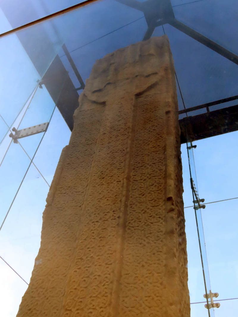
Suenos-Stone-Ringed-Cross-Side

But it’s the abundance of motifs on the back which is most striking.

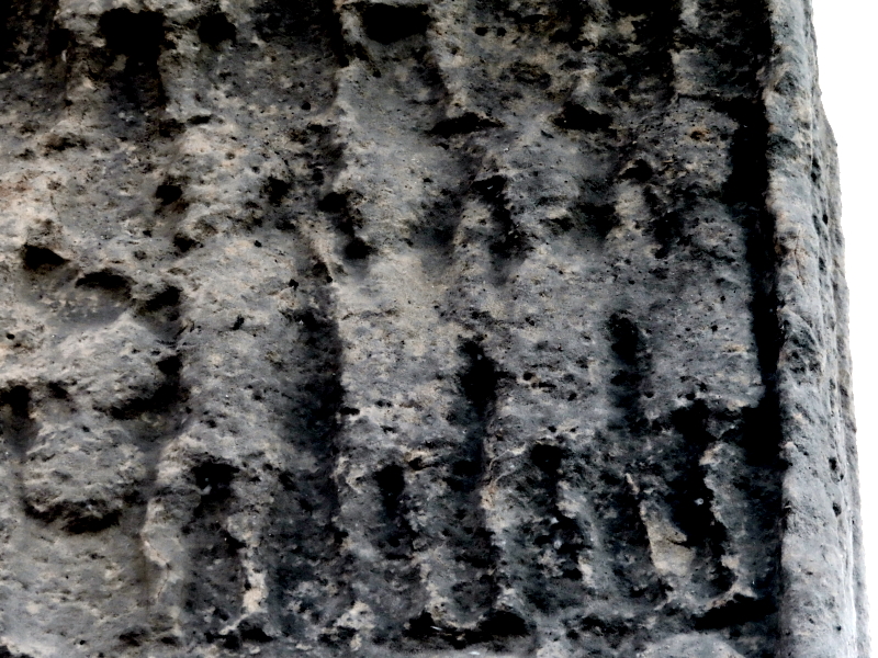
Across 4 separate panels, densely-packed, almost geometrically abstract-looking groups of figures ride into battle. They strike each other on the head with swords. Some appear to be beheaded corpses.
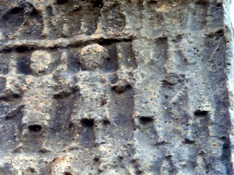
Suenos-Stone-Detail-Showing-Warriors

We have a number of possible options for the “true story” of Sueno’s Stone.

In the 10th Century, for example, when Scotland consisted of several different Kingdoms, Dubh (anglicised as Duff but meaning black or dark in modern Gaelic) was King of Alba (King of the Scots) from 962 to 967.

To place him better on a timeline, it may help to know that King Duncan the First’s dates were 1034 -1040 and Macbeth’s 1040 – 1057.

Dubh was reportedly murdered at Forres in about 967 as the result of an internal dispute among the Scots. Sueno’s Stone may be a monument to Dubh, erected by his brother.

Another possible version is linked to the man apparently known as “Sueno” – King Sweyn Forkbeard (King of Denmark from 986 to 1014) – and a battle between his Viking forces and the Scots. Because Sueno’s Stone displays mainly battle scenes, this would fit with the theory that the Picts must have had conflicts with the Vikings.

A further possibility – if the battle scene represented is one we know took place – is that it could depict a victory of Kenneth MacAlpin (who ruled from 843 to 859) or of his successor, Donald I (860-863). Their reigns strengthened the House of Alpin’s hold on this part of Scotland. In that case, the inauguration scene could refer to the enthronement of either of these important kings.

There is evidence to suggest that the stone fell or was toppled at some point around the 17th Century.

It was uncovered again within a century or so – in 1726 – and re-erected nearby. It was at this time that the name “Sueno’s Stone” was invented.

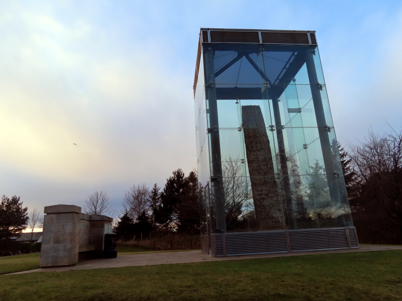
In the early 1990s, the stone was encased in reinforced glass to minimise further erosion.

Join our Newsletter for a weekly Moray update.

Delivered straight to your inbox. (See the sign-up form below).
Draining Moray

February 21, 2021 by peter brash Leave a Comment

On BBC Radio Scotland’s “Out of Doors” programme for Saturday, 20 February 2021 they were talking about drainage and how large parts of the north-east of Scotland did not previously exist as land.

They explained how, beginning about 1000 years ago, one particular part of Moray had changed beyond all recognition in the intervening period.

Here’s a brief history of local land reclamation in Moray.

It was August, in the year 1040.

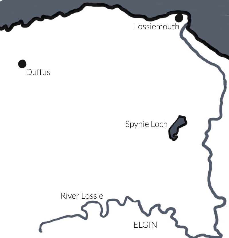
As the early morning sea mist cleared, the captain scanned the horizon, looking for the other 4 boats of the invading force. To starboard, the island of what was to become “Lossiemouth” loomed out of the haar.

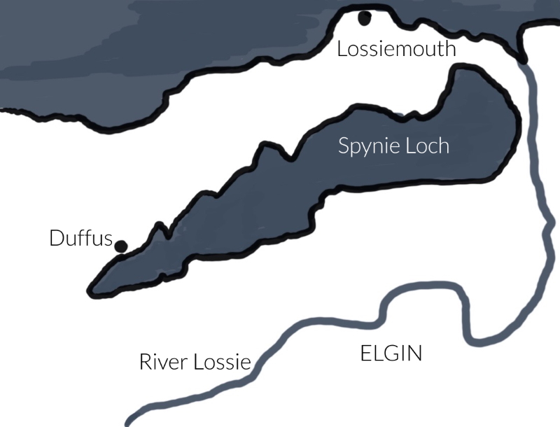
Slowly, the captain edged his ship through the narrow gap and into the massive sea loch, south to Spynie, the port of Elgin.

There, he anchored and waited.

Ghost-like, one by one the other ships of the fleet arrived. In the shallow waters that stretched before them, the skippers of the other ships lowered small boats and joined the others at the stern of the main ship to hold a council of war.

King Duncan outlined his plans for the coming battle against his cousin, Macbeth.

Duncan was to die on the battlefield at Pigaveny, near Elgin, and Macbeth took the throne.

Spynie, the port of Elgin, continued to thrive.

Spynie Loch provided a safe anchorage for fishing boats and merchant ships.

Over the years, the entrance to the loch slowly silted up and, by the Middle Ages, navigation was virtually impossible.

Spynie Loch by around the mid-17th Century, after it lost its ‘sea loch’ status.

As the extensive freshwater wetland evolved, many landowners surrounding the loch looked to land reclamation projects in Holland, Loch Leven and the Norfolk Broads with interest.

Around this time, Loch Leven had been lowered by around 4 1/2 feet to create additional land and wealth for those who owned ground by the water’s edge.

The Lairds and the Bishops of Moray were envious of these land creation schemes.

Already, along the coast at Loch of Strathbeg, a wind-powered pump was steadily lowering the waters to expose more farmland. The South Loch in Edinburgh had been drained in the 1720s to form the Meadows. Draining lochs was high fashion and very lucrative.

Thomas Telford was consulted in 1808.

The plans were to construct a canal to drain this vast area which is now rich farmland and home to RAF Lossiemouth. At that time, though, any runways would have found themselves well underwater.

At a cost of £12,000, one of the men who constructed the Caledonian Canal, Mr William Hughes, created the channel which would drain Spynie Loch, with a small amount of wetland retained for sporting purposes. The landowners gained 2,500 acres of fertile land, with some left for angling and wild fowling for the landed classes.

The Telford design was elegant.

Sluice gates at the end of the Spynie Canal opened when the tide was going out to allow drainage and were closed by the incoming waves to prevent the land being re-flooded.

It was an ingenious system which lasted for well over 100 years until the authorities decided that a simple and environmentally energy-neutral system needed to be replaced with powered pumps.

How the map looks today: Spynie Loch reduced to fraction of its former size.

As the loch lowered, the town of Lossiemouth – or Branderburgh – once virtually an island, took on the role of port. In addition, there was a small settlement of 51 fisherman’s cottages, built at Seatown or, as it was known locally, “Dogwall”, due to the habit of drying dog skins which were used, when blown up, as floats for nets.

Is the Moray coast ‘boring’?

Those modern-day folk who like to sail in the Moray Firth may bemoan the fact that it’s not like the West Coast. There are no islands or sea lochs to explore.

But it’s all here. (It’s just hidden from view). This landscape – the airbase, the fields – are all man-made.

Were we to switch off the pumps and open the sluice gates, we could “reclaim” the waterways of the north-east, recreate the myriad of small islands, 2,500 acres of waterways, wetlands, and reopen the port of Elgin?

Maybe not. In fact, certainly not a serious suggestion if you’re living on the floodplain or you need to travel from Lossiemouth to Elgin (or vice versa) to get to your work.

Historic road signs in Moray

February 1, 2021 by peter brash Leave a Comment

The Worboys report of 1964 revolutionised road signage in the UK.

Pre-Worboys signs remained across Moray until quite recently and you can see examples on other websites of signs for Lossiemouth and Keith (in Elgin) and Findhorn and Burghead (in Kinloss), taken within the last 10 years or so.

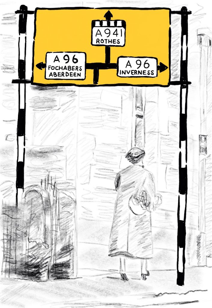
The artist’s impression, below, shows a road sign from North Street, Elgin, in the 1950s.

This is how the sign would have looked for southbound traffic on the A941, approaching Elgin High Street from the direction of Lossiemouth.

The internal ring road for the A96 which created Alexandra Road and St Giles Street was not constructed until the 1980s.

In the 1950s, North Street ran continuously from its junction with High Street right up into Bishopmill and formed part of the main A941 north-south arterial route.

The background of the sign is coloured according to the colour scheme of the time for road signs of this nature.

You can see the original image – from which the artist’s impression is a detail – on the website of Grigor & Young, Solicitors.

Road sign at the gable end of 1-7 North Street, Elgin, during the 1950s

Modern statues depicting Elgin’s historic past

November 7, 2020 by peter brash Leave a Comment

In 2016, a diverse trio of statues was unveiled in central Elgin, Moray.

On the grassy area to the east of the A96 between the Tesco roundabout and the roundabout at the Royal Mail Sorting Office stands the Wolf of Badenoch. At a height of about 6½ feet, David Annand’s creation commemorates the Earl of Buchan, infamous for setting fire to Elgin Cathedral in 1390.

The Drummer Boy (with his Dog) is at the east end of the Plain Stones close to the Market Cross.

The most controversial statue is the Dandy Lion.

To describe it as a 7-foot “mermaid lion” wearing colourful clothes, does not really prepare you for the assault to the senses it provides.

Continue Reading
Next Page »

Search this website

© 2025 yourmoray.com · Rainmaker Platform

Privacy Policy